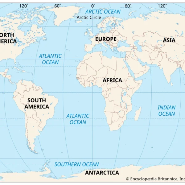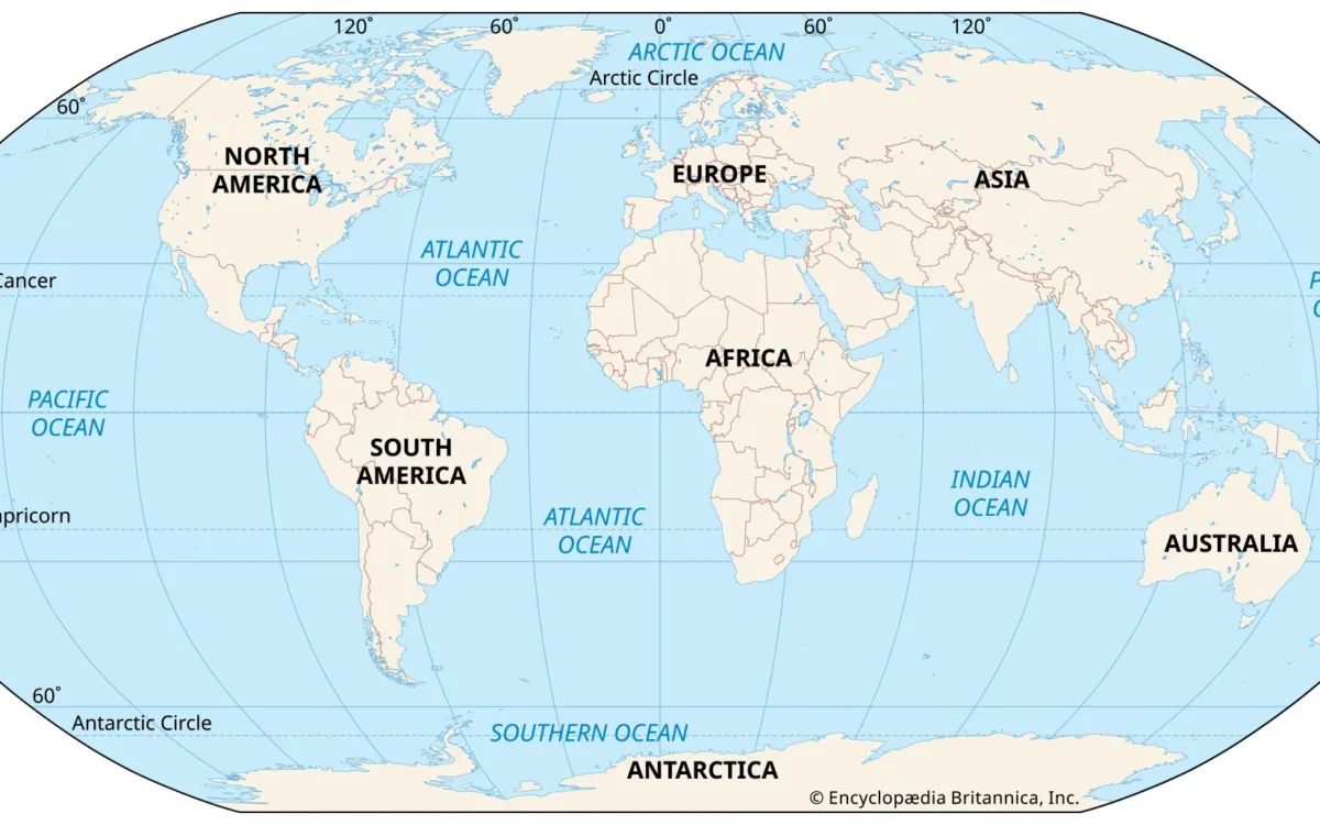
A map of continents and oceans shows all seven continents (Asia, Africa, North America, South America, Antarctica, Europe, Australia/Oceania) and five oceans (Pacific, Atlantic, Indian, Southern and Arctic). Together they account for the whole planetary surface, and ocean water makes up about 71 percent of the earth’s surface, according to NOAA.
That’s what you need to memorize. This guide goes beyond it. It provides the size rankings of the land and the water, a continent-by-ocean lookup table you can label a blank map from, and three important caveats that are often left out by most reference sources: the projection your map was drawn on, the ocean count it assumes, and the continent model its publisher followed.
What does a map of continents and oceans show?
They show two layers of information on one sheet, land masses and water basins. The image above shows both at the same time. The continents are labeled in one style and the ocean basins in another. So you can always see the land and the water.
Two lines are more important than people expect. The equator splits the map into northern and southern hemispheres. The 60 degree south line marks the northern limit of the Southern Ocean. This means that the Southern Ocean is the only ocean defined by latitude. Coastline defines the other four.
The 7 continents and 5 oceans at a glance
- The 7 continents, from largest to smallest: Asia, Africa, North America, South America, Antarctica, Europe and Australia/Oceania.
- The 5 oceans, from largest to smallest: Pacific, Atlantic, Indian, Southern and Arctic.
How to read the map’s labels, equator, and 60°S line
Water labels are in open, blue space, and run across a whole basin. Land labels are within a coastline. If a name is in between a coast and a border — the Mediterranean, the Caribbean, the Gulf of Mexico — it is a marginal sea, not one of the five oceans. Those bodies of water are part of the Atlantic System and are labeled as sub-levels, which means they don’t affect the count.
The rest of this page adds the parts a single image cannot carry: size figures, what oceans touch which continents, a printable blank version, and the reasons two atlases on the same shelf can disagree about what you are looking at.
What are the seven continents, from largest to smallest?
By land area, the order runs:
- Asia
- Africa
- North America
- South America
- Antarctica
- Europe
- Australia/Oceania
Asia is the largest by far. It is more than 17 million square miles, or about 44 million square kilometers, according to Live Science. The smallest is Australia. Antarctica sits fifth by area and is the only continent that has no permanent residents, and only research staff that rotate.
Continents are large continuous land masses. Defining them this way makes it sound like you’re defining something with a firm line. For example, where does Europe end and Asia begin? These lines are mostly cultural and historical divides that have become conventions rather than a physical rule. The Eurasian landmass is completely uninterrupted. North and South America are joined by the narrow Isthmus of Panama. Neither split is something the rock itself insists on.
Why the boundary between Europe and Asia is drawn where it is
The usual convention runs through the Ural Mountains, along the Ural River, across the Caspian Sea, and through the Caucasus to the Black Sea. Again, this line is one of agreement, not geology. That is why the unified Eurasia model a little further down this page is a valid alternative rather than an error; it simply does not draw a line at all.
What are the five oceans, and is there really only one?
By size, the order is Pacific, Atlantic, Indian, Southern, and Arctic. However, the five names really just divide up the world’s main bodies of water and describe regions, not separate bodies of water. According to NOAA, there is just one global ocean, geographically divided into distinct named areas, and you can read that framing in full in NOAA’s explainer on how many oceans there are.
That one fact changes how you read every ocean label on the sheet. Because the water is one continuous body, the lines that separate the “oceans” are really just agreements between various hydrographic bodies, not features you could sail across and notice.
Oceans ranked by size, with area figures and the deepest point
The Pacific Ocean is the largest water mass on the planet. According to NOAA Ocean Exploration, the Pacific covers more than 30 percent of Earth’s surface with a surface area of more than 155 million square kilometers (over 60 million square miles). That makes the Pacific basin larger than the landmass of all the continents combined. The Pacific holds over half of the world’s open water and almost twice as much as the Atlantic.
The smallest of the five is the Arctic Ocean which is roughly 5.4 million square miles, about 14 million square kilometers, according to WorldAtlas. Challenger Deep, the deepest point anywhere in the ocean, at the southern end of the Mariana Trench beneath the western Pacific, is recorded by WorldAtlas to be approximately 10,935 meters (35,876 feet) deep.
Which oceans border which continents?
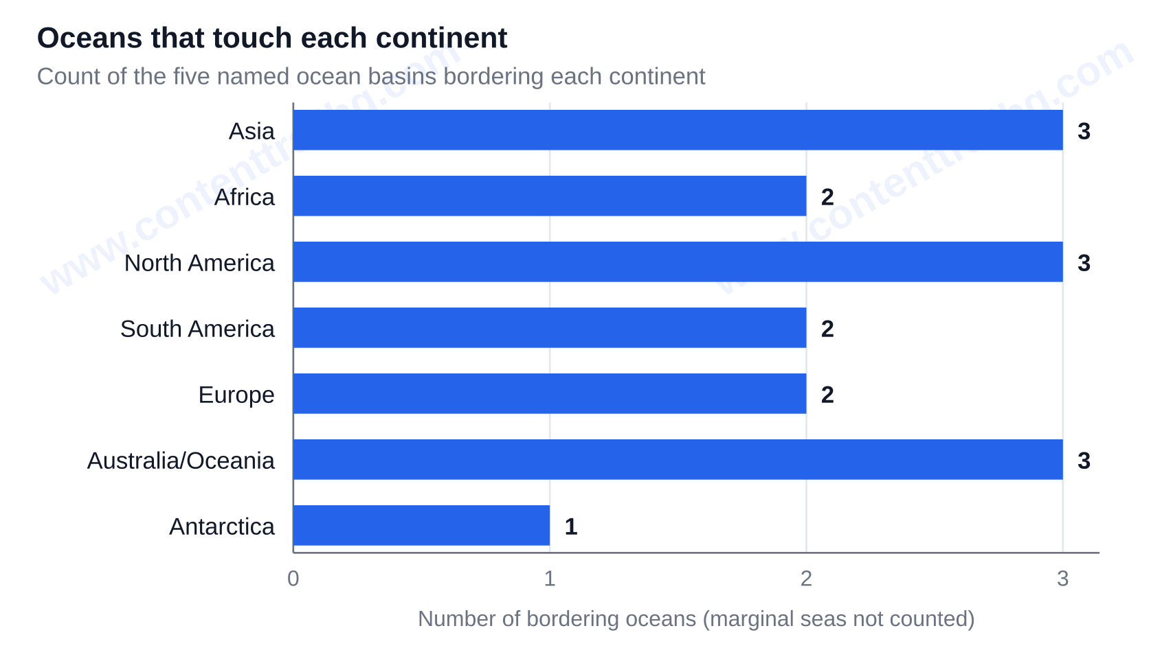
The table most webpages omit is provided here, and if you are labeling a blank outline, it’s all you will need to label your map.
| Continent | Oceans that touch it | How many |
|---|---|---|
| Asia | Pacific, Indian, Arctic | 3 |
| Africa | Atlantic, Indian | 2 |
| North America | Arctic, Atlantic, Pacific | 3 |
| South America | Atlantic, Pacific | 2 |
| Europe | Atlantic, Arctic | 2 |
| Australia/Oceania | Indian, Pacific, Southern | 3 |
| Antarctica | Southern | 1 |
Which continent borders three oceans?
Three continents, Asia, North America and Australia/Oceania, touch three oceans. The opposite is true for Antarctica, which touches the Southern Ocean completely around it.
Two edge cases catch careful labelers. First, how far the Southern Ocean reaches along Australia’s southern coast is itself debated, so published maps can vary, showing Southern Ocean water where others show Indian Ocean water. Second, marginal seas are not listed in their own column. The North Sea, Mediterranean and Caribbean Seas are all located in the Atlantic system.
While you are there, you may want to note two of the narrowest gaps between continents. The Drake Passage separates South America from Antarctica, and the Bering Strait separates Asia from North America.
Why your map of the continents and oceans may already be out of date
Contested on three fronts at the same time, the map challenges projection, ocean and continent counts. Nearly no reference page acknowledges this.
Start with projection, because it is the one you can see. What you can see is probably a Mercator or a Mercator style projection. Designed over 450 years ago to help maritime navigation, the sheet preserves direction, which is what sailors needed, and distorts area greatly as you move away from the equator. On Mercator, Greenland appears nearly as large as Africa, when Africa is about 14 times larger. It enlarges North America and Eurasia and reduces Africa and South America. The stakes and mechanics of this distortion are discussed by cartographers in The Conversation’s piece on why world maps get Africa’s size wrong.
Therefore, on the same sheet of paper, “which continent looks largest” and “which continent is largest” are not the same questions. Typically the correction is not to eliminate the old map. It is to print both and teach with the old and new maps to illustrate the distortions.
The 2026 UN resolution on map projections, in plain terms
On 4 September 2026 the UN General Assembly adopted Resolution A/80/L.104, the #CorrectTheMap resolution, by 164 votes to 1 with 6 abstentions, the United States casting the sole vote against. The resolution encourages governments, schools, international organizations and technology companies to change the projections used in their offices and classrooms to more accurately represent relative size, such as by employing the Equal Earth projection and other equal-area maps. The UN Office of the Special Adviser on Africa’s account of the vote records the tally and the text’s scope. The African Union had endorsed the #CorrectTheMap campaign in August 2025, calling for a move away from Mercator.
It is notable that this Resolution is not prescriptive; there are no mandates. This Resolution encourages, aimed squarely at the places where relative size is the point — which is exactly what a classroom wall map is for.
Mercator vs Equal Earth: what changes when you switch
The Equal Earth projection was developed in 2018 by an international team of cartographers specifically to correct Mercator’s area distortions. As you’ll see by taking a look at Equal Earth, size and proportional representation are shifted. Africa grows and asserts itself at the center. Greenland shrinks to something closer to its actual footprint. Antarctica stops being an endless white band across the bottom. Continent shapes bend slightly in exchange, because no flat map can keep both area and shape honest at once.
Why do some maps show four oceans and others show five?
Some atlases show four oceans, some five. Both can be defensible, depending on the convention your old atlas and your new one are following.
Traditionally, the world’s oceans have been classified as the Atlantic, Pacific, Indian and Arctic. In most countries, including the United States, the Southern (Antarctic) Ocean is considered the fifth. The Southern Ocean stretches from the Antarctic coast to 60 degrees south latitude, and is recognized by the U.S. Board on Geographic Names.
How the Southern Ocean became the fifth ocean
The National Geographic Society began officially recognizing the Southern Ocean on 8 June 2021, World Oceans Day, citing differences in ecology and ocean currents. Along with revising their publications, they set about updating the maps and atlases they have produced since 1915. The society’s version excludes the Drake Passage and the Scotia Sea — one more reason recent maps can still differ in detail.
Why the IHO still hasn’t ratified its boundaries
The Southern Ocean boundaries were proposed to the International Hydrographic Organization in 2000 and, to date, have not been ratified because not all member countries support the proposals. Geology.com cites the same broader issue regarding published maps of oceans: there is no worldwide agreement regarding the limits of the world’s oceans.
Best guidance for anyone grading a worksheet: if a student responds four, the honest framing is that five is the current convention and four is the older one. One response is dated, not wrong.
How many continents are there — 5, 6, or 7?
The response depends on which country produced the map. Four active classroom models exist, and none of them are errors.
In the U.S., U.K., India, China and much of the English-speaking world, the standard model of continents is the seven-continent model. This is the model reflected in the labeled map on this page.
The first of the six-continent models combines Eurasia: Africa, Antarctica, Eurasia, North America, Oceania, South America. It follows the landmass rather than the cultural boundary at the Urals. This model is taught in Russia, Japan and parts of Eastern Europe.
A second six-continent model combines the Americas: Africa, America, Antarctica, Asia, Europe, Oceania. This is the model used across Latin America as well as Spain, Portugal and Italy, where “America” is considered to be one continent, not two.
Five-continent models generally count only the inhabited continents, excluding Antarctica, and are commonly reflected in the five Olympic rings.
Use the model your curriculum or exam board uses. Label your map and indicate which model you are using. A map that says which model it follows is more useful than one that pretends there is only one.
Where can you print a blank map of the continents and oceans to label?
Use the downloadable set on this page. The set includes a fully labeled reference map; a plain map with no labels at all; a map with only the five ocean basin lines; and an answer key. The plain maps are provided in both Mercator and in Equal Earth projections, to demonstrate to learners the differences in size and shape of the continents in the two projections.
A labeling sequence that reduces errors
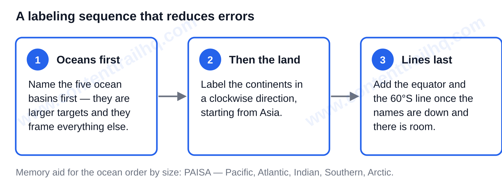
Since oceans are larger targets and frame everything else, name the oceans first and then work on the continents. Label the continents in a clockwise direction from Asia. Add the equator and the 60 degrees south latitude line at the end, once the names are down and there is room to place them cleanly.
Two memory aids carry most of the load. Use the memory device PAISA to remember the ocean initials in size order: Pacific, Atlantic, Indian, Southern, Arctic. For the land, group names by hemisphere instead of memorizing a flat list of seven. This makes it much easier to recall and helps to identify where the names are located.
Quick self-check questions
Name the continents the equator crosses. Name the only continent that resides in all four hemispheres. Name the ocean that borders three of the other four. Check the key and make sure the key itself states the ocean count convention and the model of continents it is based on, to keep it honest when someone else picks it up.
The answer to keep is seven continents and five ocean basins, and the labeled map above shows you where to find all twelve features in one view. Remember the two caveats. Counting the five oceans relies on boundaries the IHO never ratified. The familiar Mercator sheet misstates the very sizes it appears to show, and it is misleading. That is exactly what the United Nations’ September 2026 resolution asks of schools. The next step is for you to download the blank map and the answer key, print the Equal Earth version beside the Mercator one, and have learners label both. When someone notices that Africa is changing shape, the map stops being wallpaper and starts being geography. There’s plenty more to dig into on Content Trail HQ.
Common Questions
Which continents does the equator pass through?
The equator passes through South America, Africa and Asia. The Asian crossing is through the Indonesian islands, which is why some sources call that region Oceania. The equator does not pass through North America, Europe, Australia’s mainland, or Antarctica. The quickest way to orient yourself on a labeled map is to know the equator separates the Northern and Southern Hemispheres: everything above it is the Northern Hemisphere, everything below it the Southern.
Can you walk between continents without crossing an ocean?
Yes, for some pairs. For example, Europe and Asia are connected by one unbroken landmass, so that crossing is more of a line on a map than a journey. The same is true for North and South America which are connected by the narrow Isthmus of Panama, and Africa and Asia are connected by the Sinai Peninsula. Antarctica and Australia/Oceania are the exceptions. Both are surrounded by water, so there is no land connection to either of those continents.
Is Oceania the same thing as the continent of Australia?
Not quite, and it makes a difference when labeling maps. Australia is the continental landmass. Oceania is the wider region that includes Australia, New Zealand, New Guinea, as well as the island groups of Melanesia, Micronesia, and Polynesia. When it comes to seven-continent maps, either name can be printed, so you should check which label your atlas uses. “Australia/Oceania” is the safest way to write it on an answer key.